
Historical Markers in Cherry County
Discover the rich history of the area by visiting each of the historical markers scattered across the Sandhills of Cherry County.

Opening the Sandhills
The first ranch in this area was set up on the Niobrara River about five miles south of here in 1877. E. S. Newman established his ranch to sell cattle to the government for delivery to the Indians at the Pine Ridge Agency to the north.
The sandhills, later to become the heart of Nebraska’s cattle country, were shunned by Newman and his contemporaries who set up ranches on their edge. The cattlemen believed the region of shifting sand dunes, with few streams or other known sources of water, would not support cattle and was even dangerous for humans.
In the spring of 1879, Newman and his fellow ranchers were forced to enter the sandhills hoping to salvage a small portion of the stock that had drifted south of the Niobrara River in the severe winter storms. They found the cattle had both shelter and good grass and water in the hills. Since then Nebraska’s sandhills have acquired a thicker and more stable covering of grass. This rolling country with its plentiful vegetation and its diamond-like lakes nestled between the hills has become one of the most productive cattle-raising regions in the world.
Location:
42° 47.999′ N, 102° 0.787′ W. Marker is near Bayonne, Nebraska, in Cherry County. Marker is on U.S. 20, on the right when traveling east.
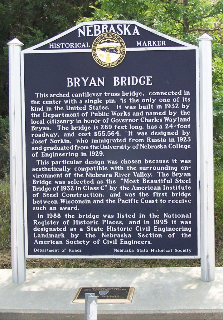
Bryan Bridge
This arched cantilever truss bridge, connected in the center with a single pin, is the only one of its kind in the United States. It was built in 1932 by the Department of Public Works and named by the local citizenry in honor of Governor Charles Wayland Bryan. The bridge is 289 feet long, has a 24-foot roadway, and cost $55,564. It was designed by Josef Sorkin, who immigrated from Russia in 1923 and graduated from the University of Nebraska College of Engineering in 1929.This particular design was chosen because it was aesthetically compatible with the surrounding environment of the Niobrara River Valley. The Bryan Bridge was selected as the “Most Beautiful Steel Bridge of 1932 in Class C” by the American Institute of Steel Construction, and was the first bridge between Wisconsin and the Pacific Coast to receive such an award.
This particular design was chosen because it was aesthetically compatible with the surrounding environment of the Niobrara River Valley. The Bryan Bridge was selected as the “Most Beautiful Steel Bridge of 1932 in Class C” by the American Institute of Steel Construction, and was the first bridge between Wisconsin and the Pacific Coast to receive such an award.
In 1988 the bridge was listed in the National Register of Historic Places, and in 1995 it was designated as a State Historic Civil Engineering Landmark by the Nebraska Section of the American Society of Civil Engineers.
Location:
42° 49.897′ N, 100° 31.53′ W. Marker is near Valentine, Nebraska, in Cherry County. Marker is on U.S. 20 3 miles west of U.S. 83, on the left when traveling west.
Fort Niobrara

When a Sioux Indian reservation was established north of here in Dakota Territory in 1878, early settlers in the region grew fearful of attack. They requested military protection, and in 1880 Fort Niobrara was built a few miles east of present-day Valentine. There was no later Indian trouble in the immediate area, and the Ghost Dance religion in the early 1890’s brought the last major Indian scare. Among the officers once stationed at Fort Niobrara were John J. Pershing, later commander of U.S. forces in World War I, and Frederick W. Benteen, a survivor of General Custer’s ill-fated staff. Fort Niobrara was an active post until 1906. In 1912 part of the original military reservation was set aside as a national game preserve. It has since become Fort Niobrara National Wildlife Refuge, with ranges maintaining sizable herds of buffalo, elk and Texas longhorn cattle.
Cherry County, a center of cattle production, was organized in 1883 and named for Lieutenant Samuel A. Cherry, a Fort Niobrara office killed in the line of duty. Valentine, founded in 1882, was named for early-day congressman E. K. Valentine.
Location:
42° 50.984′ N, 100° 32.082′ W. Marker is in Valentine, Nebraska, in Cherry County. Marker is on U.S. 20 at milepost 198, on the right when traveling west.
DEWITTY/AUDACIOUS
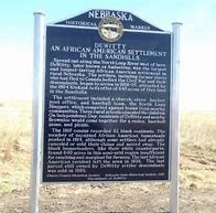
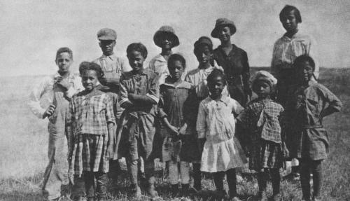
Spread out along the North Loup River west of here, DeWitty, later known as Audacious, was the largest and longest-lasting African American settlement in rural Nebraska. The settlers, including former slaves who had fled to Canada before the Civil War and their descendants, began to arrive in 1906-07, attracted by the 1904 Kinkaid Act’s offer of 640 acres of free land in the Sandhills.
The settlement included a church, store, barber, post office, and baseball team, the North Loup Sluggers, which competed against teams from nearby communities. Three rural schools educated the children. On Independence Day, residents of DeWitty and nearby Brownlee would come together for a rodeo, baseball game, and picnic.
The 1910 census recorded 82 black residents. The number of occupied African American homesteads peaked in 1914, although some settlers had already canceled or sold their claims and moved away. The black homesteaders, like their white counterparts, found 640 acres in this semi-arid region insufficient for ranching and marginal for farming. The last African American resident left the area in 1936. The last parcel still owned by DeWitty settler descendants was sold in 1993.
Located in the Sandhills of Cherry County, Nebraska, the settlement of DeWitty was established in 1908 by black homesteaders who constructed housing made of stacked sod. These settlers farmed some of the least hospitable land in the state. The families were spurred to the area by the 1904 Kinkaid Act, which allowed settlers to claim large-but-undesirable parcels of land with poor irrigation and little vegetation. Those who accepted the challenge were known as Kinkaiders.
Among the first to arrive in 1907 were Charles Meehan, born in 1856 in Detroit, Michigan, the son of white parents who had immigrated the previous year from Counties Tipperary and Fermanagh in Ireland. Charles had moved with his mother to Canada as a youngster. Joining Charles in the move from Canada to Nebraska was his wife Hester Catherine Freeman, born in Canada in 1856 to a Canadian father and a mother from Baltimore, Maryland. According to Catherine Meehan Blount, their granddaughter, Charles and Hester left Canada for Nebraska in 1885 with their oldest children and the families of Joshua Emanuels, George Brown, and William Crawford. Other early black homesteaders included Clem Deaver and Robert “Daddy” Hannahs. Meehan’s granddaughter, Ava Speese Day, later wrote about their experiences on the Plains in Sod House Memories.
They settled in an area along the North Loup River near Brownlee, calling their town DeWitty, after the first postmaster, Miles DeWitty. In 1916, a change in postmasters prompted a change in the town name to Audacious, followed by a post office relocation two years later to the town of Gard.
For a while, the homesteaders found some success as ranchers raising beef cattle, mules, poultry, and hogs. A few had dairy cows and sold surplus product in nearby Seneca. Even though they were in the proximity of the North Loup, few of the black settlers were able to claim land with water rights or even grazing meadows. So most had to purchase hay for feeding and lease easements for water access, adding to their financial burden. To make ends meet, some men worked as freighters or laborers for neighboring white ranchers while women washed, worked in kitchens, or served as midwives.
The town of DeWitty/Audacious included a general store, the St. James A.M.E. Church, and three schools. Books were borrowed from the State Library at Lincoln through a program to service rural families. Other supplies were purchased through trips to Brownlee or Seneca, or mail order from Sears, Roebuck and Company. During the early 1920s, the town had an all-black baseball team called The Sluggers, which played several undefeated seasons. However, by that time, most of the original homesteaders had found the land unprofitable and had left the area. In the late 1980s, only one ancestor of a black settler still owned land along the North Loup.
On April 11, 2016, a dedication ceremony for a new Nebraska State Historical Marker in Cherry County commemorated DeWitty as the longest and most successful African-American rural settlement in the state.
Click Here to Watch an NPS story on Dewitty –https://nebraskastories.org/videos/the-dewitty-settlement/
Midair Collision of P-47 “Thunderbolt” Fighter Planes, 1944
At 10:45 a.m. on February 5, 1944, 1st Lt. John B. Beatty of Sandusky, OH, and 2d Lt. Earnest W. Fanslau of Mantua, NJ took to the air from the Ainsworth Army Air Field in two P-47 “Thunderbolt” fighter planes for an instrument training flight. Lt. Fanslau’s canopy was covered so he could fly solely by instruments, while Lt. Beatty flew nearby as Fanslau’s observer. During the flight Lt. Fanslau made an unexpected right turn that Lt. Beatty could not avoid. Rancher Everett Morris did not see the P-47s collide but he heard the impact and observed the planes falling from the sky southeast of his ranch buildings. Lt. Beatty’s P-47 went into a flat spin, fell almost straight down, and landed on its back with very little scattering of the wreckage. Lt. Fanslau’s P-47 caught fire and exploded in midair, spreading debris over a considerable area. Both pilots were killed. The two crash sites are within half a mile of each other in the Nebraska Sandhills, approximately 15 miles south of Wood Lake near Cherry County’s eastern border.
Location:
42° 38.111′ N, 100° 14.24′ W. Marker is in Wood Lake, Nebraska, in Cherry County. Marker is on U.S. 20 at milepost 221 east of Main Street, on the right when traveling west. This marker is located in the hamlet of Wood Lake